Wir lernen Ihre Sprache noch!
Wir arbeiten fieberhaft daran, alle Seiten auf milestonesys.com in so vielen Sprachen wie möglich verfügbar zu machen. Aber dieser Prozess braucht Zeit. Während alle unsere Funktionen mehrsprachig sind. Einige Seiten, wie diese hier, sind noch nicht in Ihrer Landessprache verfügbar.
Vielen Dank für Ihr Verständnis!
GIS mapping
Enhance situational awareness through spatial data with video management software and other video technology.
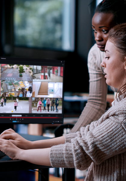
Upgrade security and decision-making


Boost decision-making and situational awareness with spatial data
Geographic Information System mapping (GIS) is a technology that brings together spatial information from multiple sources and presents it in three dimensions. It is used for mapping and as an integration, management and visualization platform. GIS mapping can integrate multiple unconnected geographic, security and safety applications and devices to analyze it spatially and control it through one comprehensive user interface.
Aided by GPS, remote sensing, the internet and the globalization of data, GIS mapping supports time-sensitive decisions, drives faster response times, saves costs, increases efficiencies and helps to inform decisions about a project or an area.
There are many applicable sources and an increasing density of information for GIS mapping. Geo-referenced sensors, such as traffic, weather, vehicle and shot detection can be combined with information from environmental, weather, news- or intelligence-based data services.
GIS mapping then presents superior 3D and 4D situational awareness of complex information, and the ability to integrate live and recorded video streams in 2D or directly embedded in 3D. Augmented reality adds an additional graphical layer on top of video imaging showing interactive items and can support detailed projections of the future.
Integrating GIS mapping with your video management software (VMS) can facilitate safety with incident detection, security- and safety-related incidents, and fleet monitoring.
Our Partners
(37)

Frequently asked questions
Commonly asked questions and answers about GIS mapping.
Get the Milestone advantage
Rely on Milestone video technology, with solutions proven in 500,000+ customer sites and 25 years of experience in the industry.


Book a demo
Book a one-to-one demo
See Milestone in action with a demo that's customized to your business and needs.